Since 2017, Chris Short has been working on a University of Reading led five-year innovative collaborative project, LANDWISE, which will join forces with farmers, advisors, communities and local authorities across the West Thames area to learn how different land management methods impact on flood risk.
A great deal of attention recently has been given to ‘slowing the flow’ within river channels using wood to create leaky barriers. LANDWISE (LAND management in loWland catchments for Integrated flood riSk rEduction) aims to take a step back and look at how to reduce the volume of water entering river channels in the first place, and to ‘slow the flow’ by enabling water to move slowly below the ground surface. This can be done by increasing the amount of water that can be absorbed by land and returned to atmosphere through crops and trees, or stored in deep groundwater.
These natural methods, including crop choice, land preparation, building soil organic matter and tree-planting, can reduce the amount of water that runs off the land surface. They improve soil structure to allow more rainwater to infiltrate below ground.
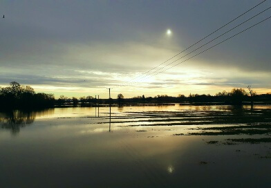
The LANDWISE research focuses on the West Thames River Basin area, where around 112,000 properties are at risk of flooding if rivers burst their banks, almost 10,000 are at risk of groundwater flooding, and many more are in danger of surface water flooding. Work will initially focus on the Loddon, Pang and Upper Thames catchments, before being scaled up to the Thames river basin upstream from Oxford and Maidenhead. The project will explore whether broad scale changes in land use and management could have helped to reduce the severity of flooding events of July 2007 and the winter of 2013/14.
The research team will gather data to test how effective these measures are for small to large flood events and from local to large river basin scale. They will bring together local knowledge on current land management methods, record how they impact water infiltration and storage below ground using field measurement and new satellite technology, and run modelling experiments based on the data collected and local knowledge. This will be supported by workshops and further field visits, working together with farmers, communities and local authorities.
The team will aim to find realistic opportunities for future Government policy on land use and management changes after Britain leaves the EU. Natural flood management measures could also improve water quality, biodiversity and sustainable food production.

The scientists will also carry out further study into the potential risk of more flooding that could be caused by increased infiltration and storage of water in deep groundwater if it results in higher groundwater levels.
The LANDWISE proposal was one of only three to be backed with funding from the National Environmental Research Council’s (NERC) £4.1m Understanding the Effectiveness of Natural Flood Management (NFM) program, and will receive £1.25m.
Chris will lead the CCRI element of the project, focusing on gathering the views of farmers and land managers to consider the acceptability and feasibility of natural flood management on their land, as well as gathering the views of local communities and policymakers. The project will report by March 2022 and is already feeding into policy developments.
In March 2020, Chris Short presented a webinar related to NFM.
Related Research Papers: Incorporating technical and farmer knowledge to improve land use and management for natural flood management in lowland catchments
Modelling the effectiveness of land-based natural flood management in a large, permeable catchment
CCRI Ref: 2016-105